Irreconcilable Imaginaries: Representations, Landscape, and Conflicting Temporalities of a Large Dam in the Upper Euphrates
When I first visited the town of Keban for my research, I came across a facility built not quite in the center of this stagnant town, yet not far from it either. While the historical town center was largely quiet, there was a certain amount of activity at this facility. The place consisted of a restaurant with outdoor seating and a children’s playground. It overlooked the Euphrates River, the housing built for the construction personnel on the opposite bank, and the dam. Indeed, the name of the facility means “contemplating Keban.”[1] Seen from this vantage point, the dam was the dominant figure in the field of vision, framed as an object intended primarily for viewing. In fact, the facility had a cantilevered viewing terrace featuring a heart-shaped frame that visually centered the dam (Figure 1). A little further ahead, there was another heart-shaped step-in photo frame with a bench in front of it. Sitting on the bench placed the visitor within the heart against the dam’s massive body in the background. A dam of this scale sets in motion profound ecological, social and landscape transformations. How then, did this object, which since its inception precipitated such extensive intervention, destruction, and displacement in this region, also come to be imagined as a spectacle, to be consumed visually within a heart-shaped frame?
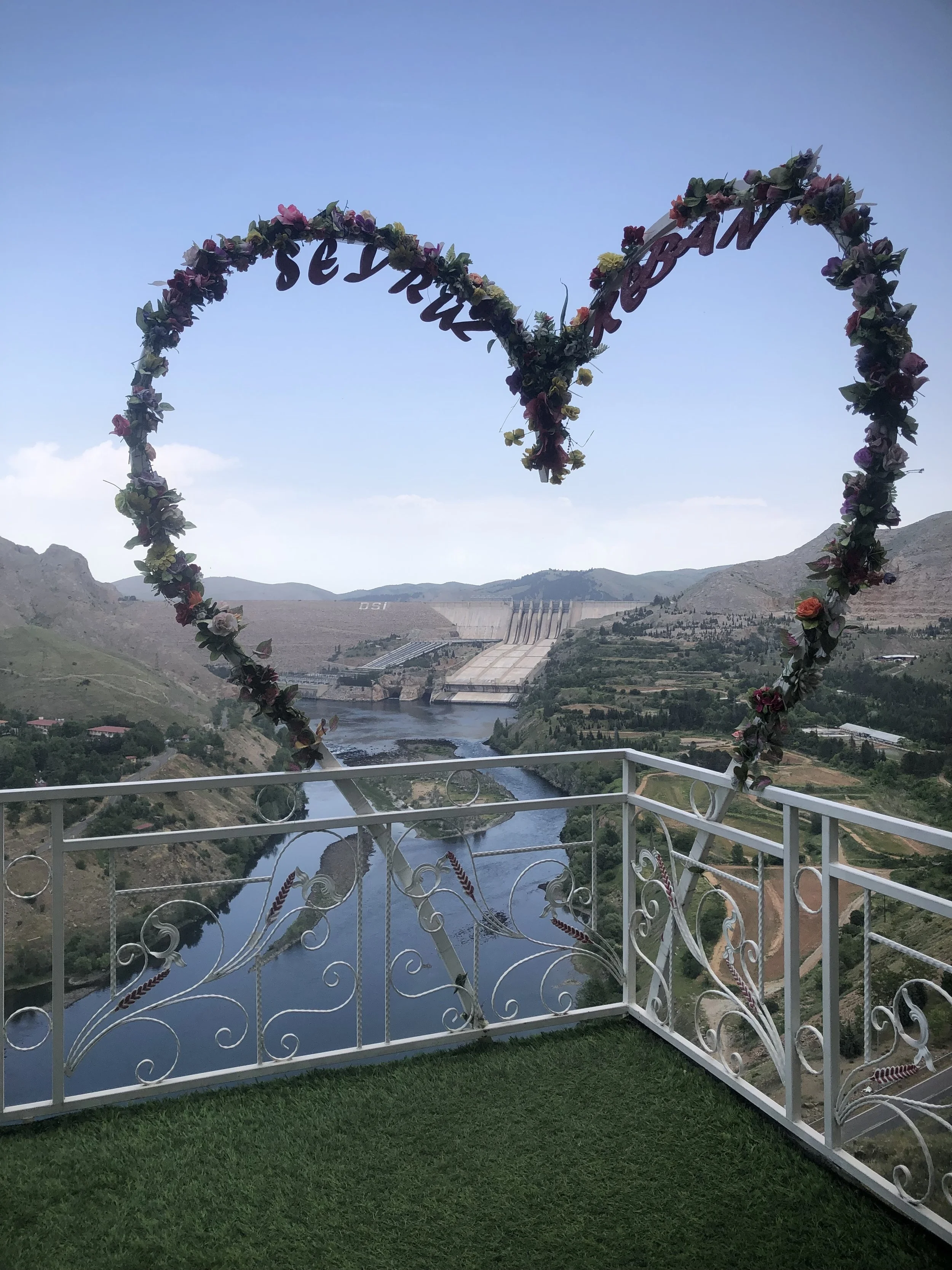
Figure 1. The heart-shaped frame in the facility in Keban, Elazığ. Photo by the author, 2024.
This seemingly contradictory situation can be explored by tracing how the dam has been imagined, represented and reinterpreted throughout its history. In this essay, I examine how the official rhetoric about the Keban Dam reframed the surrounding landscape by rendering the lived experiences of its original inhabitants—such as villagers, animals and plant life—largely invisible. To this end, I juxtapose the dominant visual and verbal discourses produced by the state with literary texts by local authors who depict the displacement and destruction instigated by the dam.
Constructing the Image of the Dam
Keban Dam was constructed on the Euphrates River between 1966 and 1975 and it was, at the time, the largest dam in Turkey and the tallest in the Middle East (Figure 2). The project was prepared by EBASCO, a New York based consultancy firm, and the construction was realized by CCI-Salini Impregilo, a French-Italian consortium. As the longest river in Western Asia, the Euphrates, together with the Tigris defines Mesopotamia, and also forms a geographical boundary between eastern and western Turkey.
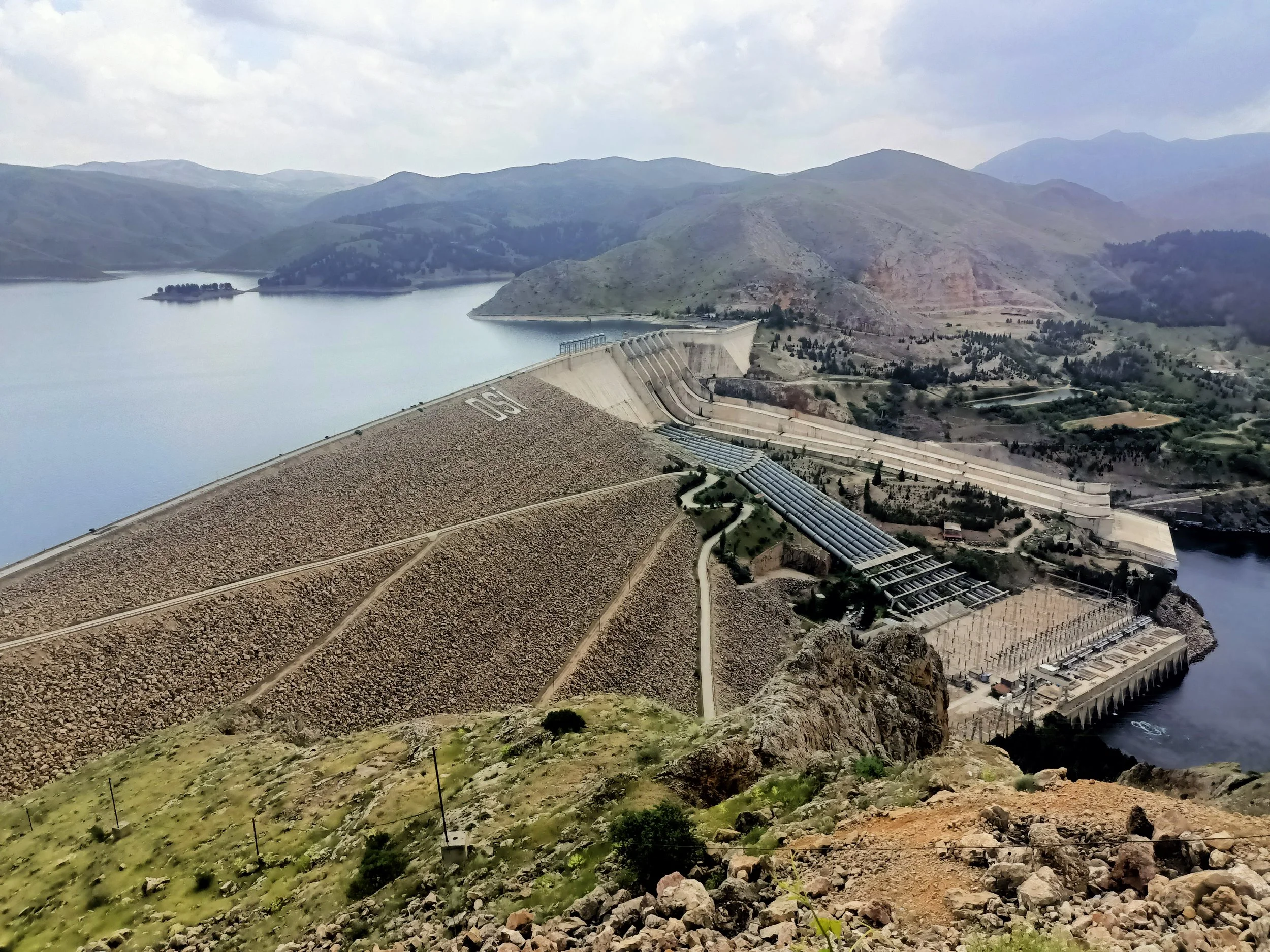
Figure 2. View of the dam from the observation terrace across from the town. Photo by the author, 2024.
In the Turkish state discourse, the East was often portrayed as backward, underdeveloped, and uncivilized. This situation was partly linked to the region's geographically inaccessible and rugged terrain. Furthermore, until the 19th century, the region was largely under the semi-autonomous rule of the Kurds. It had a heterogeneous ethno-religious composition, including Kurds, Armenians, Syriacs, Nestorians and Alevis as well as Turks. From the 19th century onwards, the East of Euphrates experienced political turbulence due to the centralization of authority. In the last decades of the Ottoman Empire, the region became the site of uprisings, conflicts, and assimilation policies that resulted in violence, exile, massacres, and displacement.[2] Consequently, it was regarded as a territory that needed to be brought under state control. In the early republican period, when nation-building policies were actualized at the highest level, the Eastern provinces became a special target of Turkification as they had a predominantly Kurdish population. As Dale Stahl, in his 2021 study of “The Dam as Catastrophe: Connecting Geological Models to Modern History points out, the Keban Dam is a massive structure built in a region that had previously undergone socially violent transformations, representing a major transformation in the physical landscape.
During the 1930s, when the Keban Dam was just an idea, efforts to tame the Euphrates were underway primarily through bridge construction. [3] This ambition was closely tied to a civilizing narrative that would reappear in the discourse surrounding the Keban Dam. Constructing a dam on the Euphrates symbolized the unity of the country, consolidating the East and the West in the national imaginary. In his speech at the dam’s groundbreaking ceremony in June 1966, then-Prime Minister Süleyman Demirel described bringing the river under control as a sign of civilization. Speaking for the Euphrates at the dam, Demirel declared "I am now at the disposal of the Turkish nation." On the same day, then-president Cevdet Sunay asserted extending the electricity grid to the Eastern and Southeastern cities would bolster the country’s territorial integrity.{4] Unlike the military interventions of the 1930s, in the 1960s the approach to Turkey’s Kurdish regions had shifted toward integrating them into the market economy. Nonetheless, an implicit anxiety about indivisibility of the homeland persisted. Consequently, the dam was imbued with symbolic meanings that transcended electricity production and interweaved multiple discourses.
The dam’s construction was highly promoted in the official discourse from the outset. It received wide coverage in newspapers, journals and official government films. Visual representations of the dam accompanied this discourse in various materials such as bulletins, brochures, booklets, technical drawings, models, maps, postcards and stamps. Visual and textual materials produced and presented throughout the dam’s history actively contributed to the framing, legitimization and dissemination of the project.
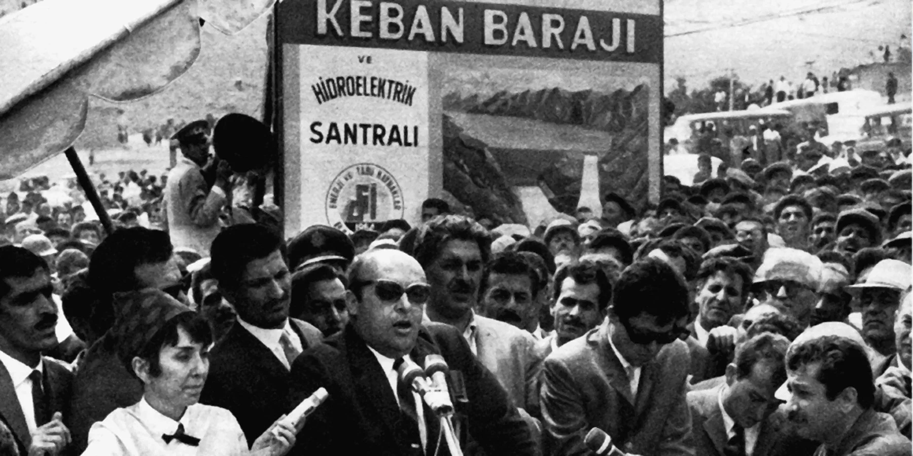
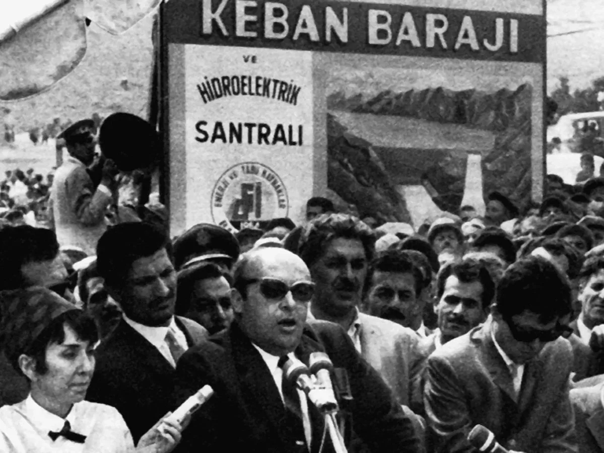
Figure 3. Süleyman Demirel at the groundbreaking ceremony in front of the rendering of the dam, June 12, 1966. https://www.k24kitap.org/once-koy-cocugu-sonra-da-muhendis-wilhelm-meisterin-degil-suleyman-demirelin-ciraklik-yillari-4250
One of the first visual representations of the Keban Dam appeared on the cover of the 1963 feasibility report by EBASCO. The same image was later used in State Hydraulic Works (Devlet Su İşleri, hereafter DSİ) bulletins and pamphlets, as well as on the large backdrop behind Süleyman Demirel at his groundbreaking ceremony speech (Figure 3). Incorporated into a descriptive black-and-white landscape painting, the dam was depicted with quite soft lines as if it were part of the natural scenery. The structure took up half of the composition, while the other half consisted of still water and the bare mountains in the background. The brochures published in 1965 and 1966, when preparations for construction began, feature colorful, poster-style illustrations. The images highlight the dam’s gray reinforced concrete body, the blue water flowing from the spillways, and the yellow electrical cables. These early covers featured artistic drawings that envisioned the complete project, while later depictions documented the construction process in detail, highlighting the specific phases as they unfolded (Figure 4). In addition to images, the dam was also represented through models in the İzmir International Fair (1965) and Erzurum Eastern Fair (1972). The models were built at a scale that allowed people to walk around them (Figure 5). The captions accompanying photographs of the models on exhibit conveyed unbridled pride[5].
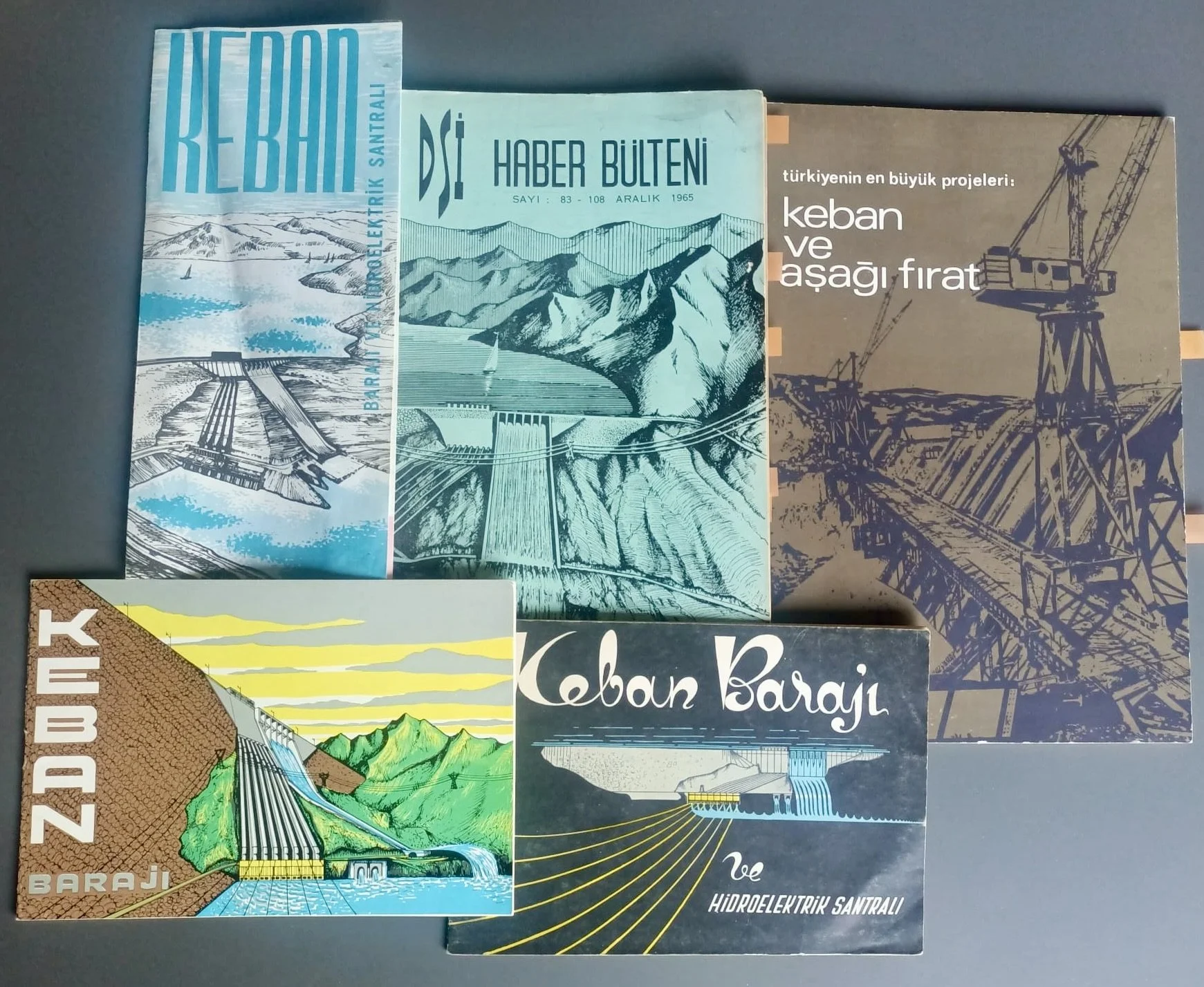
Figure 4. A collage of the visual representations of the dam. Personal archive of the author. (1) Brochure, Keban Barajı ve Hidroelektrik Santralı, DSİ Matbaası, 1968; (2) DSİ Bulletin, December 1965; (3) Türkiye'nin En Büyük Projeleri: Keban ve Aşağı Fırat, DSİ Matbaası, 1970; (4) Booklet, Keban Barajı, 1966; (5) Booklet, Keban Barajı, 1965.
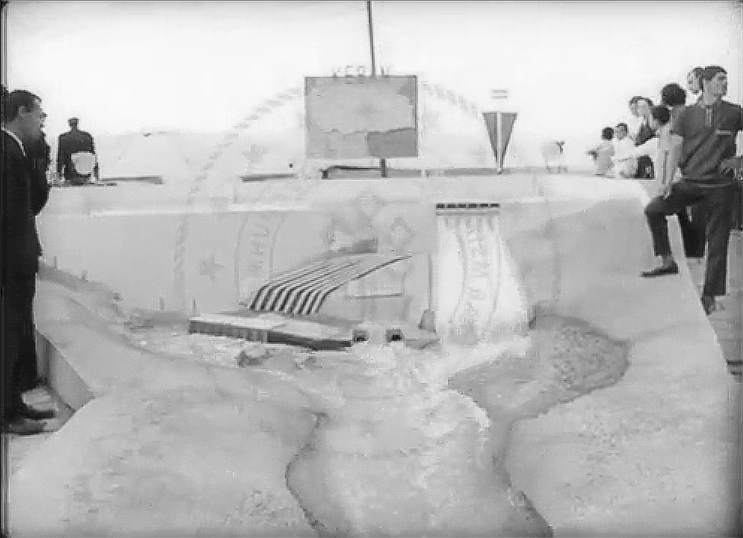
Figure 5. Model of the Keban Dam in Erzurum Eastern Fair, 1972. Footage from the video Erzurum Eastern Fair produced by the Prime Ministry Directorate General of Press accessible via General Directorate of Cinema, Turkish Ministry of Culture and Tourism: https://filmmirasim.ktb.gov.tr/tr/film/erzurum-dou-fuar
Official visual representations consistently foreground the dam itself, emphasizing its technical specifications and construction process, focusing on it as a monumental and individual artifact. Yet, while the creation of a reservoir lake of approximately 675 square kilometers was highlighted as a major achievement, the inundation of 212 settlements, which radically altered a culturally and historically layered landscape, including cultivated lands, historical monuments, and archaeological sites, barely received coverage. (Figure 6). The dam displaced communities which the public authorities had already tacitly factored in as a necessary sacrifice inherent to the project. The villages to be submerged were scarcely ever mentioned, reduced to mere statistics and points on maps.
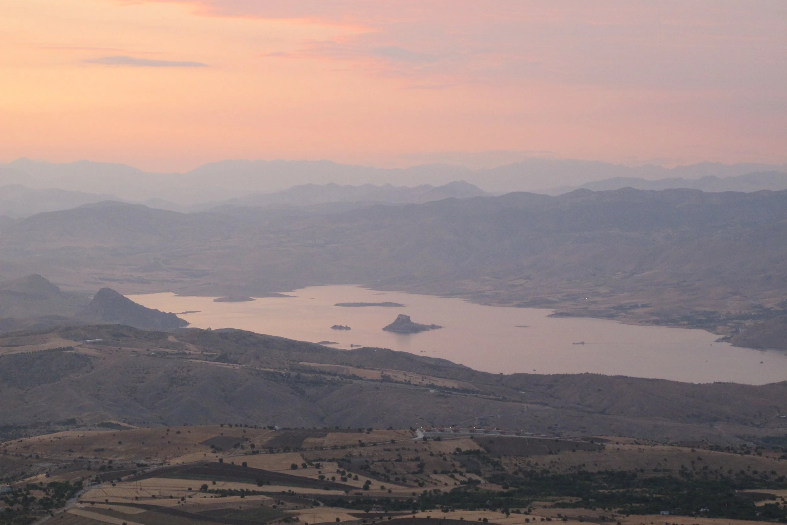
Figure 6. Part of the Keban Dam reservoir lake between Elazığ and Pertek from Harput. Photo by the author, 2025.
Counter Narratives and Conflicting Temporalities of the Dam
As the local author Mustafa Tuncel depicts in his novel set in a village of Keban during the construction, almost everything about the dam itself was calculated, documented, and archived. In contrast, information gathering about the settlements and landscapes to be submerged was limited. This asymmetry was also reflected in the maps of the future reservoir that circulated in official publications. The maps show the reservoir as a monochrome or blue blotch, and the villages are represented by dots within it. The number of villages represented by these dots varies from map to map, and their names are sometimes misspelled: (e.g., Aşvan-Avşan, Pinoğlu-Pinoğut, and Coravan-Corayan). This careless and negligent spelling casts in sharp relief the official attitude toward the places sacrificed for the dam (Figure 7). Beyond such reductive representations, archival traces of the submerged villages are remarkably scarce. Except for the documentation produced from 1967 to 1975, as part of the Keban Dam Rescue Project (KDRP), records of these places are almost non-existent. The KDRP reports constitute a rare body of material, including measured drawings, photographs, and information on the social and historical structure of the villages derived from interviews though they primarily focus on archaeological surveys and excavations.
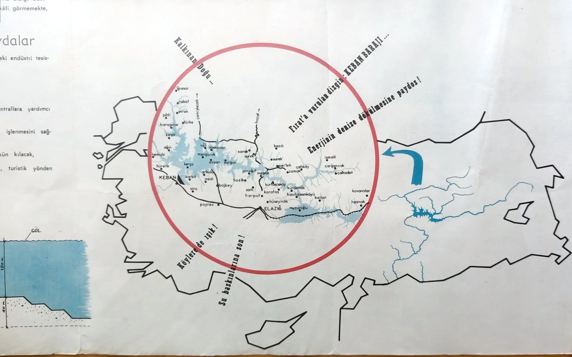
Figure 7. Map from a DSİ brochure (1968) depicting the reservoir area with several misspelled village names; personal copy.
DSİ Matbaası, Keban Barajı ve Hidroelektrik Santralı, 1968.
While discussing how little archival material exists about the everyday lives of displaced people and the submerged landscape of the Keban Dam, Stahl notes that this absence—as a negative space—has something to say. The questions left unanswered and the evidence not found reflect a broader historiographic logic in which grand projects and ancient civilizations are prioritized over the everyday lives of local people. Nevertheless, there are sources, albeit limited, containing "bits of information" about local life as traces for historians to follow. Stahl refers to official surveys indicating the size of the displaced population and salvage excavation reports as examples. Following Stahl’s insight that only fragments of information exist on this issue, here I trace the landscape and the lived experiences of the local people, who were silenced by the dominant historiography of the dam, through a series of texts that might be called the poetics of a dam. These literary works draw on the personal experiences of the authors, who hail from the places they describe. These local authors offer counter-narratives that demonstrate how different the rural landscape and lived space were from what state discourse, reports, technical drawings, and calculations depicted. In these texts, fiction, semi-fiction, and personal narratives intertwine. I consider them as counter-narratives because they render visible the gap between the civilization the state promised with a dam and the tragedy it caused.
While the Keban Dam is associated with concepts such as development, energy, and enlightenment in the official discourse, literary texts addressing the dam articulate a shared disaster narrative- one that is largely rendered invisible. In Kolo (1979), by Vedat Dalokay, for example, the rising waters sweep away all living beings and people shortly after the dam gates are closed. Dalokay likens the impoundment of the water to Noah's Flood, depicting the event as an annihilating rupture. Mustafa Tuncel's novel Suda Kurudu Kökler (Roots Withered in the Water, 2000) describes Keban during the dam's construction, particularly the village of Büklümköy, for which the displacement of its inhabitants was a catastrophe. In Pertek'in Önü Kelek (Keleks[6] at Pertek, 2025) by Ergüder Öner, the disaster takes the form of a boat accident, recounting the losses that occurred while villagers attempted to navigate the Murat River, which had been transformed into a reservoir lake. The story emphasizes how these new conditions required different survival skills and introduced new patterns of movement in space. Read together, the literary works do not merely recount different experiences caused by the dam, they present alternative temporalities and spatialities that challenge the linear narrative of progress in official discourse.
To discuss how the Keban Dam was portrayed in the official discourse and what this discourse neglected, it would be worthwhile to look at the accounts titled “the History of the Keban Dam” published in bulletins of State Hydraulic Works (Devlet Su İşleri, DSİ) during and after the construction of the dam. These texts were periodically revised and republished while retaining a largely consistent chronological structure. They present the project as a linear sequence of technical milestones- from early observations in the 1930s to feasibility studies in the 1960s, followed by a construction timeline culminating in the dam’s completion and inauguration in the 1970s.
In contrast, for those living upstream, the dam’s construction was experienced as a gradual disappearance rather than a linear narrative of progress. While a giant structure arose in the Keban gorge, together with the supporting workers’ camps, lodgings, and facilities around it, simultaneously, a major transformation was underway in the area to be submerged. Even before the waters rose, the landscape was already being unmade. For example, a 1974 Associated Press news video, captured the dismantling of the reusable materials from houses, which produced a ruin-like landscape.
The impoundment of water in the reservoir was a significant milestone in the construction process, celebrated with some fanfare in November 1973. As described in a DSİ bulletin, "The Keban delegation carefully observed the transport of the 35-ton floodgates by trailer and their lowering into their sockets. They were also informed about the areas that would be submerged and thus never be seen again.”[7] For those living there, this marked the beginning of an anxious wait. The timing of the rising waters was indexed to the agricultural cycle. The submerged lands were quite fertile and the crops grown there were the main source of livelihood for the locals. Notably, the land to the south-east of the city of Elazığ is known as Altınova (Golden Plain) for its bountiful crops. In the AP documentary, a farmer crouches on the wall of a ruined house and describes how fertile the land that grew these vegetables and fruits, is now being submerged. “Now it's ruined. What can we do? We have nothing. We're leaving. The village wasn't like this. It was a very beautiful village. The Pertek district depended on this village. During the watermelon season, 50 or 60 loads would go from here to the Pertek market, to be sold." In Dalokay’s Kolo, villagers in Borkini continue to cultivate their fields despite being told the waters will rise, and, as expected, their efforts are rendered futile (Figure 8). Kilometers away from Pertek, just behind the dam, Asya Ana (Mother Asia) of Suda Kurudu Kökler sows her land for the last time a year before leaving her village . It has been announced that in two years the dam will be completed and the waters will inundate the area. Thereafter, Asya Ana measures the remaining time by how many more seasons she can plant her land.
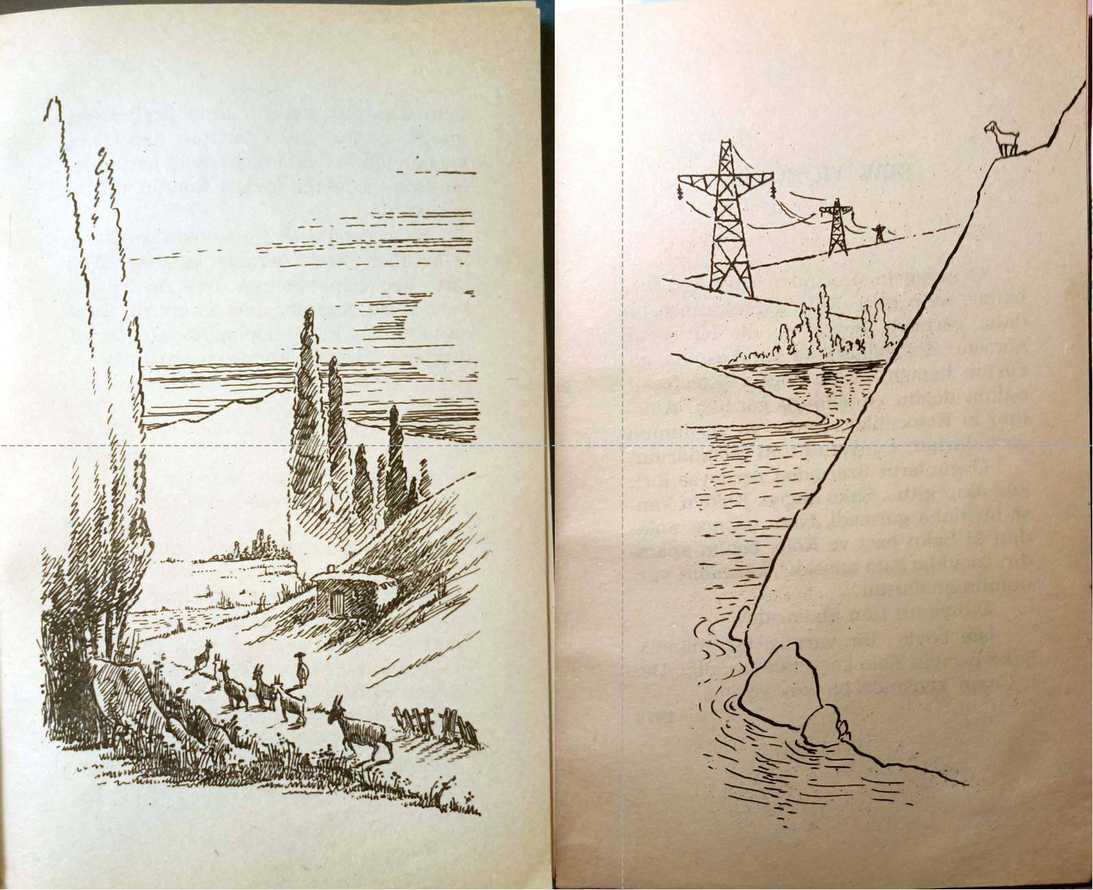
Figure 8. Illustrations depicting the village before and after the dam by Tan Oral in Kolo, 1982; presented here juxtaposition.
The submerged landscape included cemeteries and places of symbolic significance as well as houses, fields and vegetable gardens. For instance, a church in the submerged village of Til in Pertek, was one of the three churches documented but not preserved during the Keban Dam Rescue Excavations. Following the mass deportations and massacres in 1915, the region was no longer inhabited by Armenian parishioners, yet surviving Armenian communities visited it on religious occasions. The church was not only a cultural heritage object, but also a site of pilgrimage. Natural elements also defined sacred sites for those who attributed meaning to them. While the technocrats measured rise of the waters in terms of the amounts required for the dam’s operations and the commencement of electricity production, local inhabitants marked it through the gradual disappearance of the familiar elements of the rural landscape—fields, trees, and rocks. From the state's perspective, trees were cut down because they lay within the boundaries of the future reservoir lake. For the Alevi community, who have nature-based rituals, however, these trees were sacred landmarks.[8] In one of the stories in Kolo, Dalokay recounts the book’s protagonist, Şako Bacı’s (Sister Şako) visit to Sultan Hıdır’s shrine to make a vow to increase her nanny goat Kolo’s milk yield. On the way, she prays at a juniper tree growing out of a “purple rock” between two mountains and ties a headscarf to its branches. In the chapter titled “The Dam,” Dalokay, returns to the village only to encounter the same juniper tree submerged and decayed beneath the rising waters.[9]
In Tuncel’s novel, the water level is narrated through the sequential submergence of landmarks such as “the hawthorn tree in Asya Ana’s field,” “the blind girl’s mulberry tree,” and the “blood-stained rock.” In Kolo, too, the waters first cover all the streams flowing into the Murat River. They then engulf the tree the author names Tatlı Şakuk, a sweet wild pear tree and the water source known as Üç Pınarlar (The Three Springs). Finally, they reach the almond trees, fields, and houses.
In official documents, the timeline for the dam’s construction was defined through laying the foundation, excavating diversion tunnels, constructing spillways and holding water. In contrast, in the submerging villages, the water’s rise was understood as a sequential destruction of the rural landscape, the interrupted cyclical planting time of the land, disrupted rituals and displacements.
Rescripting the Landscape
On various occasions, such as its anniversaries, Keban Dam is still celebrated, and the narrative constructed around it is reproduced. Yet how is the dam and its reservoir area reinterpreted at the material level? What replaces those submerged landscapes and lived experiences of the locals? Beyond the discursive celebration of the dam, the reservoir landscape has also been materially reconfigured. These interventions portray the area as a space of leisure and spectacle, incorporating it into the experience economy in a way that glosses over histories of displacement and destruction of landscape.
The Keban Dam was associated with a number of promises, one of which—though it was less frequently mentioned than the others—was that it would create new recreational and tourism-related facilities in the region. Yet EBASCO’s 1963 report predicted that it would be many years before Keban Reservoir Lake would be able to offer recreational benefits, citing that Turkish people had not yet “reached the point” at which they would consider engaging in leisurely outdoor activities, a framing that seems to assume a linear progression in recreational demand. Furthermore, the cost of equipment for water sports or other recreational activities was beyond the means of the average Turkish worker. [10] Indeed, the Keban Dam reservoir area did not become an active recreational area as promised. Only in more recent years, privately operated tourist-oriented facilities have begun to emerge. These initiatives appear to have been developed independently from a comprehensive regional plan. Among them is a dining and trout farming facility established on a waterfall in Keban formed by water leaks during the dam construction and presented as “the youngest waterfall in the world” (Figure 9). Along the waterfront downstream from the dam, there is an accommodation and zipline area. A restaurant is located by a disused historical mining cave, where colorful lighting installations in the former shafts are presented as visitor attractions (Figure 10, 11).
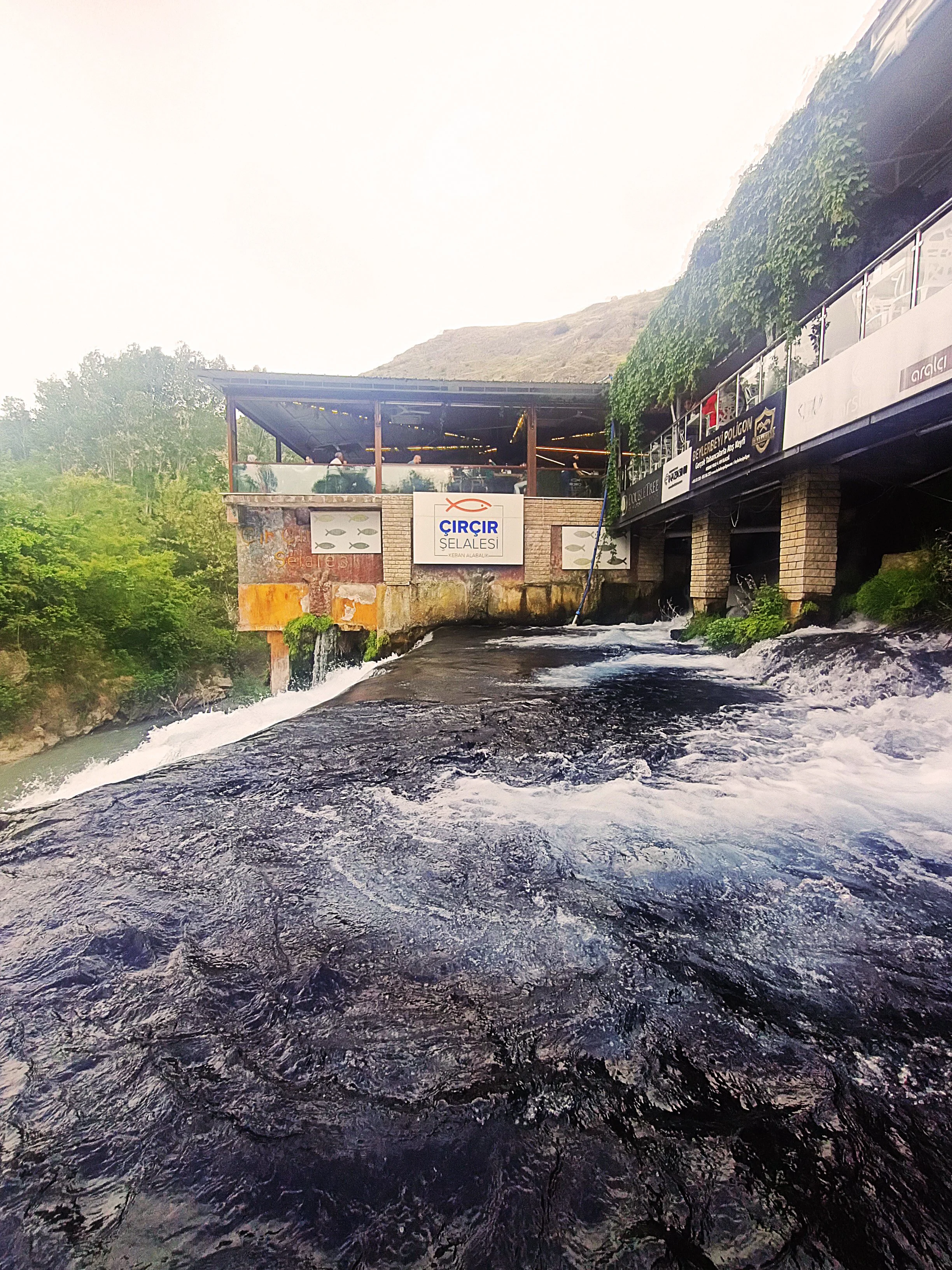
Figure 9. The restaurant was built on the waterfall. Photo by the author, 2024.
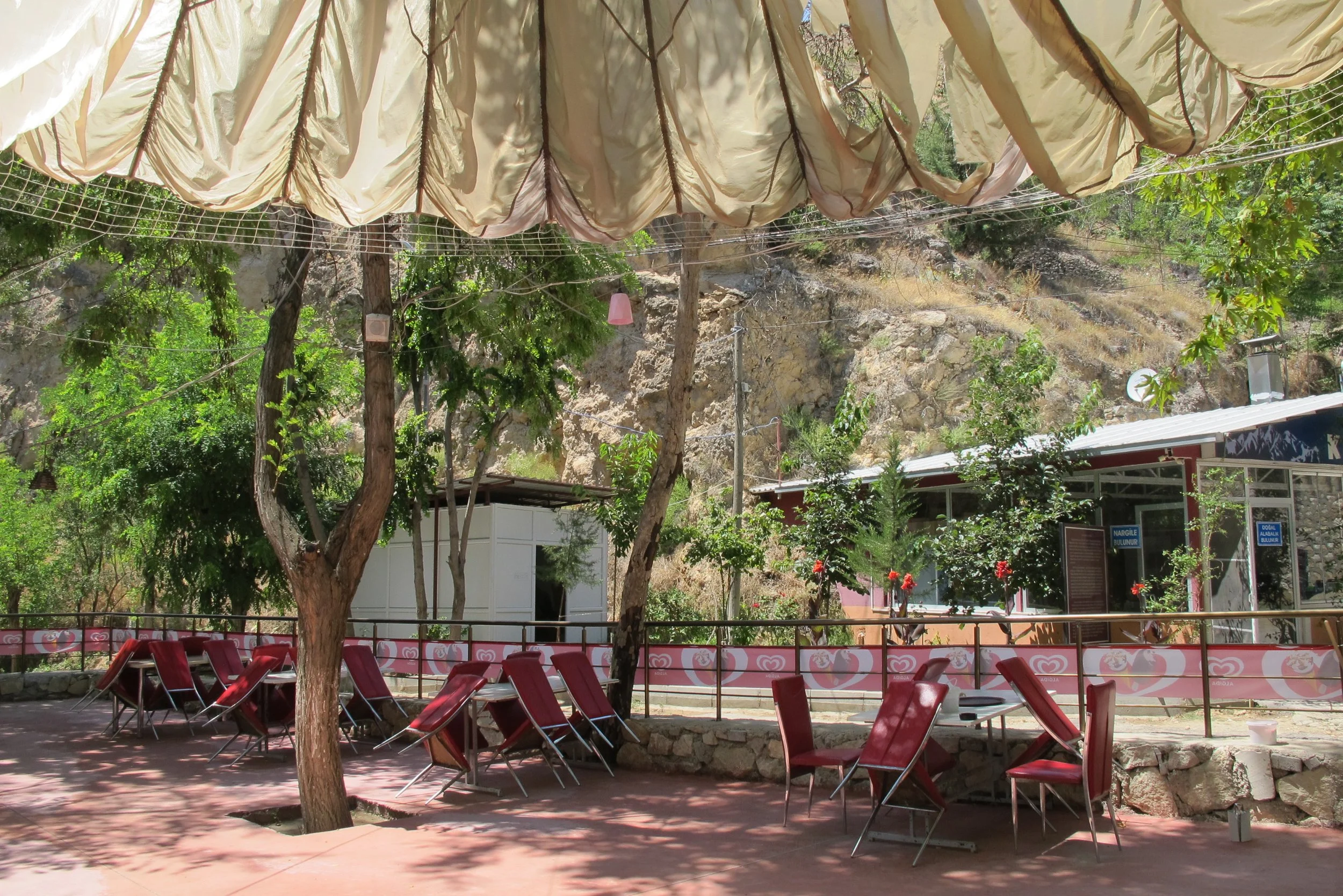
Figure 10. The entrance of the restaurant adjacent to the entrance of the cave. Photo by the author, 2025.
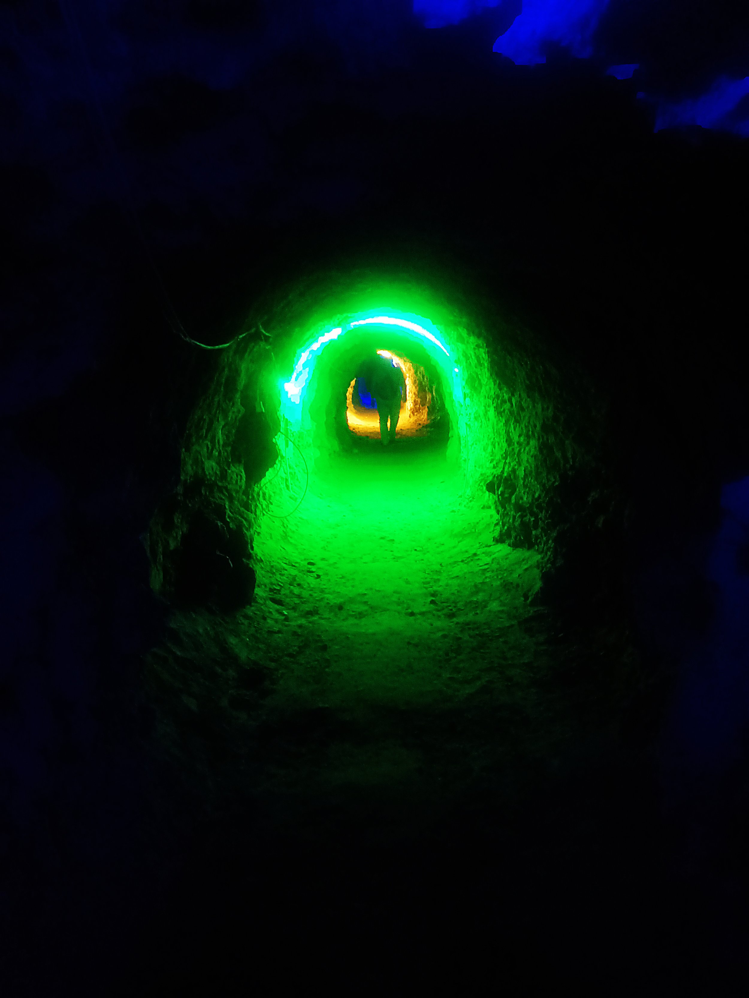
Figure 11. Through the illuminated tunnel. Photo by the author, 2025.
A more recent example of this reconfiguration can be found in Pertek, where a water sports center affiliated with the Ministry of Sports and Youth was established in 2019. The center originated in a project entitled “Keban is Not an Obstacle, but Life,”which ironically acknowledges the dam’s widespread perception as an impediment. Initiated in 2015, the center was developed through a partnership between the district governorship and the municipality and funded by the Ministry of Development and a ministry-affiliated sports organization. The center is promoted through news reports in national agencies and local outlets. The activities such as canoeing and rowing are praised in these reports and often accompanied by carefully staged photographs. From the news reports, it is understood that these are venues that operate periodically, coming into play during planned events or official visits, rather than being used regularly by locals. Thus, the landscape is staged periodically as a site of spectacle for outsiders rather than being incorporated into the local societal and cultural environment.
In short, the dam and the gradual conversion of its environs into objects of spectacle are the reason these establishments exist. These sites portray the reservoir as a place for short visits rather than a site for everyday activities, and their spatial logic caters to outsiders rather than local communities. They have largely been implemented without a broader framework that considers the natural, cultural, and historical values of the region with a consistent approach.
The facility with the heart-shaped frame introduced at the outset, together with the sites such as trout farming with a restaurant in Keban, contribute to the ongoing reproduction and stabilization of the dam’s evolving meaning. The water sports center project in Pertek, which defines itself through not being an obstacle also reinforces this narrative. The rescripted landscape continues to rewrite the history of the dam and the region, rendering the submerged rural landscapes of the 1970s invisible. In contrast, this essay, though based on a few representative examples, points to the possibility of an alternative local-perspective historiography of the dam. Situating local experiences within the broader context of the dam’s history, such an account reframes linear, progress-oriented accounts by alternative temporalities revealed through everyday life in the transformed rural landscape.
Citation
Özge Kurban, “Irreconcilable Imaginaries: Representations, Landscape, and Conflicting Temporalities of a Large Dam in the Upper Euphrates” PLATFORM, May 18, 2026.
Author’s Note
This article is a revised and reframed version of a paper presented at 16th 4T Design and Design History Symposium in İzmir on November 6-7, 2025.
Notes
[1] The name of the facility is Seyrül Keban.
[2] Uğur Ümit Üngör, The Making of Modern Turkey: Nation and State in Eastern Anatolia, 1913-1950 (New York: Oxford University Press, 2011) and Zeynep Kezer, “Spatializing Difference: The Making of an Internal Border in Early Republican Elazığ, Turkey.” Journal of the Society of Architectural Historians, 73:4 (2014): 507-527. .
[3] “A Monument of Civilization The Concrete Keban Bridge on the Euphrates River” Ulus, October 20, 1937.
[4] “Cumhurbaşkanı Cevdet Sunay’ın Keban Barajı Temel Atma Konuşması,” DSİ Bülteni, Vol. 83-114, (June, 1966): 3.
[5] Ahmi Kargın, “İzmir Fuarında DSİ Pavyonu,” DSİ Bülteni, Vol. 83-116, (August, 1966): 12-17.
[6] Kelek is a raft made of inflated animal skins, most commonly used along Euphrates and Tigris
[7] “Keban’da Su Tutuldu,” DSİ Bülteni, Vol. 165, (March, 1974): 7-8.
[8] Ahmet Kerim Gültekin, “Kurdish Alevis: A Peculiar Cultural Identity at The Crossroad of Multiple Ethno-Politics,” in The Ethno-Cultural Others of Turkey: Contemporary Reflections, ed. Ahmet Kerim Gültekin and Çakır Ceyhan Suvari, 39-70 (Yerevan: Russian-Armenian University Press, 2021): 46.
[9] Sultan Hıdır / Üryan Hızır Shrine is located in Zeve / Dorutay village in Pertek, inland from the reservoir shoreline which suggests that the author may have interwoven two distinct stories into a single narrative.
[10] EBASCO, Report to Electric Power Resources Survey and Development Administration for Engineering and Economic Feasibility of Keban Dam and Hydroelectric Project. (New York: EBASCO Services Inc., 1963), IV- 98-99. NARA [Online version https://catalog.archives.gov/id/7433791 National Archives and Records Administration, October 8, 2024]