Reifying A Shatter Zone: the Geopolitics of Extraction in the Upper Euphrates
To read this post in Turkish, click here.
A 1941 Foreign Service Manual informed American diplomats that without the Turkish government’s permission, foreign nationals could not travel to several provinces in Eastern and Northeastern Turkey. Considering the constant threat of being swept up in the raging war that encircled them, it is understandable that Turkish authorities would be protective of the country’s territory and limit access to border regions and to strategic routes such as the Straits.
Figure 1. Superimposition of the Restricted Zone (pink) over the boundaries of the Vilayat-ı Sitte (blue). (Drawn by the author over a map adapted from the 1942 school history textbook atlas, Unat, Faik Reşit. Tarih Atlası. İstanbul: Kanaat, 1942.)
But as can be seen in this map, several of the partially or fully restricted Eastern provinces were well inside Turkey’s national territory, far from any international borders. (Figure 1) Notably though, there was a substantial overlap between the restricted zone and the Vilayat-ı Sitte (the Six Provinces), which comprised a region that due to its relative inaccessibility and rugged terrain had enjoyed a certain degree of autonomy since being absorbed into the Ottoman Empire in the sixteenth century. This region had become destabilized as the Kurdish tribal principalities that long oversaw it resisted the nineteenth-century Ottoman reforms to modernize the state and centralize authority. Concomitantly, intensifying competition among Russia, Britain, France, and, later, Germany to gain control over Ottoman territories and rising secessionist nationalisms further aggravated the turbulence in the East of Euphrates. In 1878, following the disastrous Russo-Ottoman War, various European powers stepped in to re-establish the regional geopolitical balances at the Berlin Conference. The measures they imposed included bringing the Vilayat-ı Sitte under international monitoring, ostensibly to ensure the safety of their substantial Armenian populations in the face of rising ethno-religious strife. Not only did Ottoman officials consider this arrangement a profound and humiliating intrusion over state sovereignty, but saw it—with some reason—as part of a larger plot by the Great Powers to sever the region from the empire altogether.
So great was the shock of the empire’s rapid and catastrophic unraveling in the ensuing decades, culminating in its barely averted post-WWI partition, that even after largely reclaiming the territorial reconsolidation they sought and gaining release from the monitoring regime, the founders of the Turkish Republic were gripped by lingering anxieties over foreign meddling and their inability to bring this region into the fold. Turkey might have achieved international recognition on paper with the 1923 Lausanne Treaty, but with no internal pacification on the ground, its leaders felt compelled to proscribe access to the country’s East from the mid-1920s onwards.
“…Analyses of this enduring relationship have often been consigned to a realm of abstract calculations as if such geopolitical alignments were merely ephemeral and could be forged with no lasting material implications.”
An Abandoned Silo in Maden
Yet, if traces in the built environment are anything to go by, then clearly this proscription was selective and strategic. That Turkey and Germany had a history of wide-ranging collaborations since the early nineteenth century and that in the first decades of the Republic, Germany was Turkey’s preferred partner for a whole host of modernization projects is no secret. But analyses of this enduring relationship have often been consigned to a realm of abstract calculations as if such geopolitical alignments were merely ephemeral and could be forged with no lasting material implications. To the contrary, this relationship left an enduring imprint on the built environment and landscapes of a region Turkish officials sought to jealously shield from prying foreign eyes.
Figure 2. The abandoned silos at the back of a parking lot in Maden (Elazığ). Photo by the author.
Figure 3. The abandoned silos at the back of a parking lot in Maden (Elazığ). Photo by the author.
A case in point is a large and inscrutable concrete structure in Maden prefecture, ensconced at the back of a small parking lot just off the road (Figures 2-3). Using this now abandoned artifact, which once was part of a crucial supply chain, as a starting point, it is possible to chart out an expansive map of highly transactional and ethically complex geopolitical relations that in turn reinforced this region’s characteristics as a shatter zone.
Figure 4. The Maden Prefecture Building, ca 1880, currently under restoration in August 2023. Photo by the author.
Figure 5. The modern smelter at Ergani Maden Copperworks (source: Yazman, Aslan Tufan. Etibank 1935-1945. Istanbul: İktisadi Yürüyüş Matbaası ve Neşriyat Yurdu, 1945.)
Figure 6. Ergani Maden Copperworks, general view of the main production area with the smelter in the background (source Yazman, Aslan Tufan. Etibank 1935-1945. Istanbul: İktisadi Yürüyüş Matbaası ve Neşriyat Yurdu, 1945.)
Maden itself was home to a sizable copper mine since prehistory and even served as an Ottoman administrative center in the late nineteenth century (Figure 4). Though mining had largely ceased during the empire’s final years, it was revived under the republic to aid the national industry and economy. Yet, due to lack of human, financial, and energy resources, expertise and technology, combined with the challenges of an inhospitable terrain and an inadequate road network, it took nearly fifteen years to install a modern smelter in Maden so as to purify the copper. The much-anticipated expansion of the rail network to Maden in 1935 finally expedited this project’s completion, and linked copper production to the port of Mersin for export (Figures 5-6) This new route was part of a broader reconfiguration of Turkey’s transport network, recasting the movement of goods and people within its shrunken post-WWI geography (Figure 7).
Maden gained further significance as a strategic shipping nexus a year later, with the start of chromite mining in Guleman. Initially, the chromite was carried to Maden on beasts of burden on a torturous steep and narrow mountain path, though the road was soon paved to facilitate trucking. Compared to the growing demand, however, the capacity was miniscule. Consequently, within the first year of operations, Poehlig, a Cologne-based German company, rushed an 18 km-long diesel-powered aerial tram fitted with 180 cars between Guleman and the Maden train station. (Figure 8)
Figure 7. A map of Turkish Railways as of ca 1935. Highlighted is the route between Maden and the Port of Mersin. Projected on an existing Turkish State Railroads Map by the Author (source for base map Cumhuriyet Halk Partisi. On Beşinci Yıl Kitabı. Ankara: Cumhuriyet Matbaası, 1938.

Figure 8. The chromite deposit silo at Maden, terminus point of the aerial tram system built by Poehlig to transport raw ore to Maden for shipment to the Port of Mersin. The train cars awaiting deposit can be seen at the bottom. (source: Yazman, Aslan Tufan. Etibank 1935-1945. Istanbul: İktisadi Yürüyüş Matbaası ve Neşriyat Yurdu, 1945.)
The tram increased the transport capacity exponentially. By 1938, Guleman’s chromite production rose tenfold to 95,000 tons a year, accounting for nearly 60% of Turkey’s entire output. Although open-pit mining was a seasonal activity, the aerial cars whizzed year-round, bringing ever larger amounts of chromite to Maden to be shipped via Mersin for processing in Germany. So remote was Guleman that the tram also became the principal means of relaying vital supplies—such as food or medicine—from Maden and occasionally transporting people when the roads were closed in the winter.
Several major German companies, such as Krupps, Thyssen, and Siemens were involved in these endeavors in Maden, Guleman, and beyond. The roster in the State Mining Technical and Research Institute reports attest to the scope of assistance German geologists, chemists, material scientists and engineers provided in exploring and developing these mines and the installation of their production facilities.
Maden and Guleman expanded with many of the trappings of European company towns. They featured single family homes in garden plots for the ranking administrative and technical personnel, dormitories for bachelors most of whom were seasonal workers, small clinics, and various social, educational, and recreational facilities—including movie theaters, swimming pools and tennis courts that would have been quite outlandish for the locals at the time. As such they were intended—albeit with a large dose of unrealistic paternalism—to offer the local, mainly Kurdish populations, models for a “civilized lifestyle” (Figure 9).
Figure 9. Single family housing for high level administrators in Guleman (postcard from author’s personal collection).
Finding an Ally in Difficult Geopolitical Conditions
What intensified the Turco-German relationship at this juncture was necessity: following WWI, both countries had been severely sidelined in international relations and trade. The two quickly rekindled their longstanding collaboration, while Turkey and Britain haggled over Kirkuk and Musul in the 1920s, and the latter quite successfully pressured its wartime allies to marginalize Turkey politically and economically. Turkey’s leaders wanted to transform the material conditions of life in their country. They sought to instigate legal educational reforms, develop industries, improve transport and communications networks, and consolidate the national market and Germany had been waiting in the wings to assist from the outset.
While challenges abounded throughout Turkey, the East posed particular difficulties in implementing these objectives. It had become, in the aftermath of the Armenian Genocide, a desolate and depopulated place. Even official voices, without quite pronouncing what had actually happened, recognized that, bereft of its Armenians, it was deprived of their knowledge and skills in cultivating this land, the cultural and commercial networks they once animated, and that their absence exacerbated the widespread state of abject poverty.
The Kurds, who constituted the remaining majority, had at best an ambivalent relationship with the state. Although they had mostly thrown their lot with the current leadership to fight the post-WWI occupation, they were now taken aback by the republican leaders’ demands not just for subservience, but cultural assimilation. When the latter jettisoned the Caliphate (ostensibly in pursuit of secularism, but in practice, trying—not too subtly—to bring religion under state control) the Kurds felt further unmoored. Tensions persisted, frequently erupting into violent conflicts, which linger on to this day.
In short, in the precarious geopolitical environment of the interwar years, Turkey’s leaders fretted not only about external threats on the country’s territorial integrity, but also—and perhaps more pressingly—about internal challenges to their authority especially in the East of Euphrates. To bolster the state’s capacity for deterrence at home and abroad, they turned to Germany. But the Weimar Republic was reticent for fear of violating the Versailles Treaty stipulations that strictly forbade it from developing and selling weapons. Although unofficially some former German officers served as consultants to the Turkish military and occasionally companies such as Junkers undertook projects that, much to the consternation of the German government, came close to breaching the Treaty, throughout the 20s and early 30s, German input to Turkish modernization consisted primarily of advisory roles, assistance with civilian projects, and supply of industrial goods and knowhow.
“In short, in the precarious geopolitical environment of the interwar years, Turkey’s leaders fretted not only about external threats on the country’s territorial integrity, but also—and perhaps more pressingly—about internal challenges to their authority especially in the East of Euphrates.”
All this changed in 1933 with the ascent to power of the Nazis, who decided to unilaterally dismantle the Versailles Treaty. A clearing agreement conceived in 1934 by the German Finance Minister Hjalmar Schacht made it possible for Turkey to barter its raw materials and agricultural products, which had long languished in fields and silos, with Germany’s industrial products, allowing the two to trade without cost and avoid falling further into international debt. Meanwhile, the Nazis’ priority was to develop their arsenal after a hiatus of more than a decade in the weapons industry and chrome was the sine qua non of this equation.
A brittle metal with little use on its own, chrome is a crucial alloying component for stainless steel, rendering iron harder and rust free with a wide range of industrial applications, especially in weapons manufacturing. Chrome is indispensable for producing armored plates, projectiles, tanks, munitions, aircraft, steel tubing and the like as well as that of the machinery used for the fabrication of these weapons. But Germany had no access to chrome, and if it was going to rebuild its industries, it had to import the material from somewhere. This is where Guleman came into play. All of Guleman’s high tenor chromite together with almost all of what was mined from elsewhere in Turkey was sent to Germany. So insatiable was the German appetite that Turkey had already become the world’s largest chromite exporter, producing nearly a fifth of the global output on the eve of WWII.
Contemporary Traces of a Collaboration
In exchange, Germany would provide Turkey with motorized transportation vehicles and trailers, howitzers, artillery guns of various sizes, munitions, gun powder, bombers and fighter planes in addition to helping revamp the weapons plant in Kırıkkale, near Ankara. The clearing agreement also accelerated the construction of infrastructural, military, and institutional installations in the East of Euphrates. Projects encompassed well beyond the immediate vicinity of mining sites and the construction of transit corridors for transporting the ore to port to include roads, railroads, bridges, military installations, which were intended to stitch together Turkey’s East to its West and were so favorably featured in official narratives as “the advent of civilization.” Like the now abandoned silo, traces of these structures, especially in the neighboring provinces of Dersim/Tunceli and Elazığ, are still visible—some have been put to different uses and other remain in a state of decay.[1]
Figure 10. Title page of the book “Tunceli Medeniyete Açılıyor” (Tunceli is Opening up to Civilization), published in the immediate aftermath of the Dersim Operation. A propaganda book, it was authored by Naşit Hakkı Uluğ, a journalist known for his proximity to the country’s leadership. The book describes several infrastructural projects and institutional improvements that are being brought to Dersim, now Tunceli, to bring it into the fold and civilize its peoples. (Source: Uluğ, Naşit Hakkı. Tunceli Medeniyete Açılıyor. Istanbul, 1939.)
Figure 11. A page from “Tunceli Medeniyete Açılıyor” describing the construction of new roads through the mountainous landscape of the province. (Source: Uluğ, Naşit Hakkı. Tunceli Medeniyete Açılıyor. Istanbul, 1939.)
Best described as a shatter zone, Dersim was historically home to an ethno-religiously diverse population, whose resistance to assimilation was anathema to the homogenizing propensities of the Turkish state. Escalating efforts to bring it into the fold culminated in an all-out military campaign in 1937-38 that leveled almost a third of Tunceli’s villages, killing more than 13,000 people and exiling another 12,000 to “secure” provinces in the West, using the railroad networks that were supposedly built to bring the region civilization and prosperity. (Figures 10-11) This, of all military incursions, was the one that left the most indelible mark on Dersim’s collective memory within which it is known as the Tertele (Massacre) With large swaths of Dersim cordoned off to all but permit-carrying officials, infrastructural expansion accelerated. Elazığ, meanwhile, became the state’s regional stronghold, housing the headquarters and relevant facilities of the newly established plenipotentiary Inspectorate General (Figure 12-13).
Figure 12. The former Headquarters of the 4th Inspectorate General in Elazığ, currently being used as the regional offices of the Turkish Postal Service PTT. (Photo by the author)
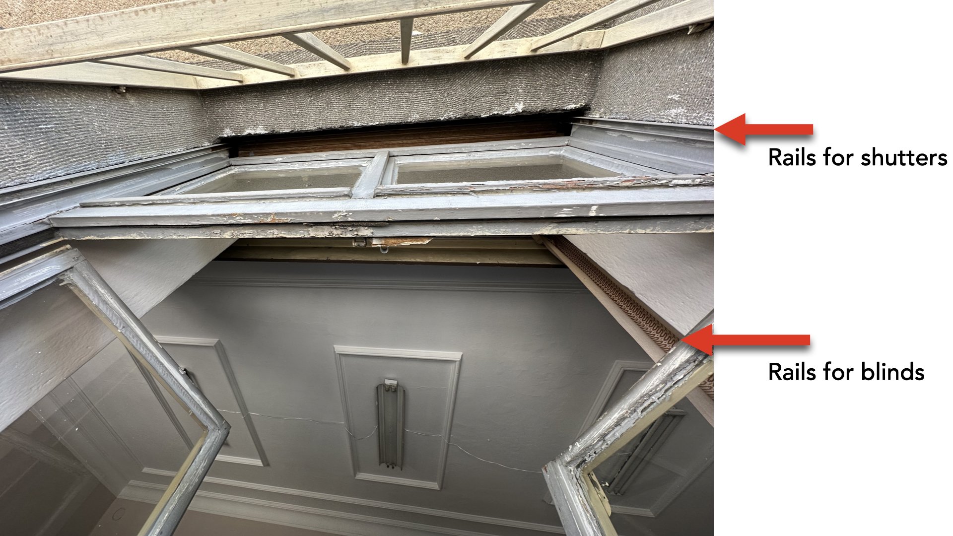
Figure 13. Window detail at the former Headquarter of the 4th Inspectorate General in Elazığ. The multilayered detail of shutters and blinds on rails is an imported technology that was new in Turkey at the time, and certainly unusual in this region. (Photo by the author).
The planning and construction of the rapidly built military installations in both provinces confirm the presence of German equipment and expertise precisely when the authorities were most eager to shield the region from international scrutiny. It is not just the distinctive compositional qualities in the massing or elevation of this these landmark barracks (figure 14-15), or the Inspectorate General’s Headquarters, but the finer details of their construction, such as the terrazzo flooring, or the multilayered window blinds, which would have required a degree of constructional precision that, especially with the Armenians gone, was not available locally.
Figure 14. Aerial view of central Tunceli, located in the village formerly known as Mameki. Two large army barracks (buildings 1 and 2) anchor the new administrative center, which was relocated from Hozat, which was harder to reach from Elazığ. The barracks in the middle ground (1) was restored as a museum and opened in 2020; the smaller one in the back is used as a recreational facility. (Photo courtesy of Tunceli Museum). The small cluster of residential semidetached houses in the foreground were built to house military officials and civil servants. (Photo courtesy of Tunceli Museum)
Figure 15. Army barracks prior to reconstruction. After serving as a barracks for several years, the building was eventually converted into housing for civil servants, thereafter, it was abandoned and became a slum for many years. The roof material as seen in the photo is unlikely to be original, but the massing of the dormers and window detailing suggest an German-inspired formal composition (Photo courtesy of Tunceli Museum).
Conveniently sequestered from international scrutiny, the Upper Euphrates was the crucible wherein an ethically complicated relationship between Turkey and Germany was forged. It was also where the Turkish state’s intensifying extractivist and assimilationist interventions began to transform local ecologies, carving new corridors of transit within the country, linking previously unconnected ports, collieries, forests, and mines transforming the nation’s geographic imaginary.
Acknowledgements
My heartfelt thanks to the British Institute of Archeology in Ankara and Newcastle University Global Urban Research Unit for their support in carrying out this research, to Mustafa Balaban and Barış Yıldırım, who served as companions and guides during my Elazığ and Dersim trips, and to Deniz Yonucu, who made sure I always remembered what is in a name.
Citation
Zeynep Kezer, Reifying a Shatter Zone: The geopolitics of extraction in the Upper Euphrates, PLATFORM, February 12, 2024.
Notes
[1] Dersim is the indigenous name given to the extremely mountainous region bracketed by the two main tributaries of the Euphrates. In 1935, as part of internal pacification effort, Dersim, which used to be a prefecture within the province of Elazığ was partitioned as a separate province, renamed Tunceli, and brought effectively under martial law. Toponymic engineering has been a common tool used to impose a sense of homogeneity and Turkicize the country’s cultural landscapes under the republic.