Mapping Fascism: What Spain’s Past Reveals About the U.S. Today
At the turn of the twentieth century, Spain found itself in a moment of profound crisis. The loss of its overseas empire in the Americas—which had culminated very publicly in the Spanish-American War of 1898—disrupted the coordinates through which Spain had long situated itself in the world, particularly at a moment when its European neighbors were continuing to expand their imperial reach. The country had been demoted in the colonial order of things.
In 1900, the public intellectual Joaquín Costa captured this condition succinctly: “We have lost the sense of space, just as we had already lost the sense of time.” [1] Costa’s statement did more than diagnose decline; it framed Spain’s crisis as a loss of orientation. The country no longer knew where it stood—either in history or on the map. The imperial geography that had once anchored both had disappeared, and no stable alternative had yet taken its place.
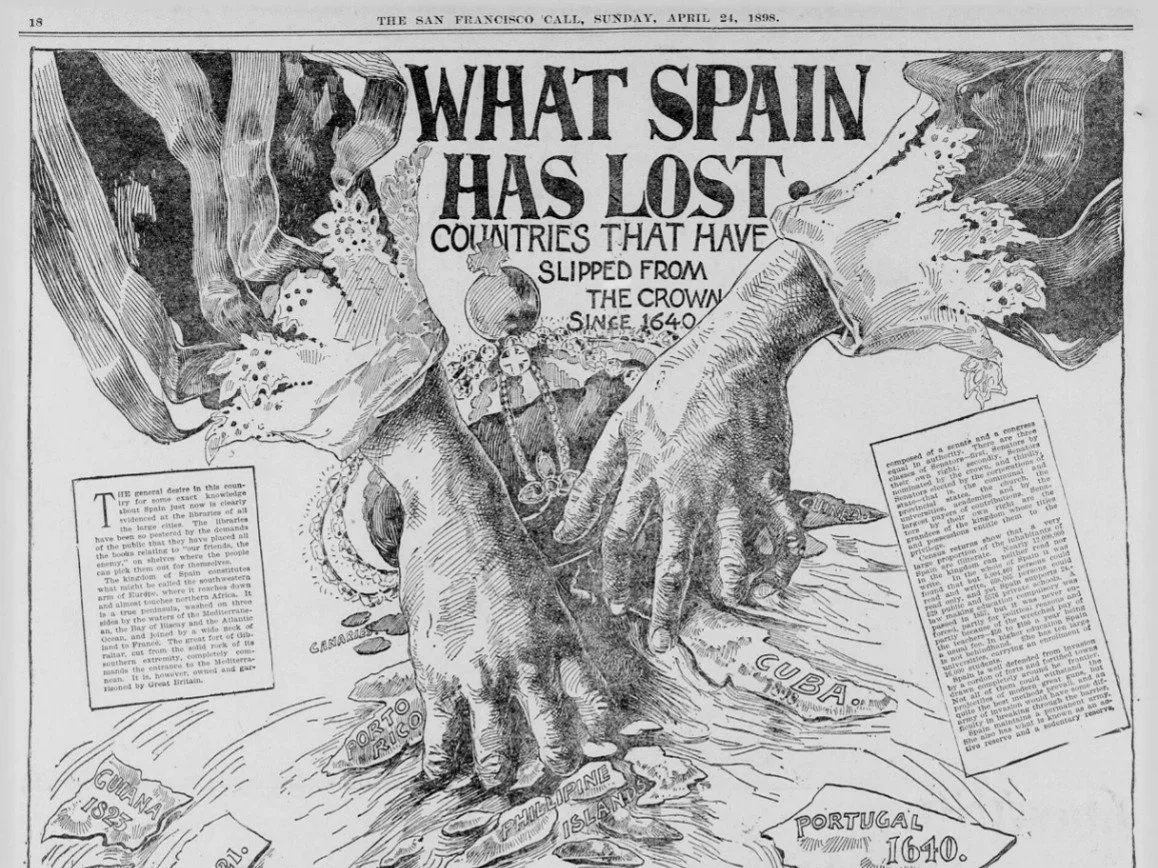
Figure 1. San Francisco Call, Volume 83, Number 145, 24 April 1898. Source: California Digital Newspaper Collection (CDNC). Permission: Public domain (published before 1923). Courtesy of the California Digital Newspaper Collection.
This sense of disorientation was not confined to political discourse. It emerged and circulated widely through a range of unassuming visual and spatial forms: American newspaper comic vignettes depicting, much to Spain’s dread, its colonies sailing away; Spanish painters taking ruinous rural landscapes as their leitmotif; atlases, schoolbooks, and governmental reports mapping Spain’s minimal colonial presence vis-à-vis its expanding European neighbors; and illustrated magazines and stamp series juxtaposing images of imperial grandeur with scenes of poverty, rural backwardness, and institutional failure (Figure 1). Across this circulation, certain recurrent motifs can be identified: collapsing borders and merging geographies, landscapes of ruins, and new colonial horizons in Northwest Africa—particularly Morocco—as a space of historical and geographical proximity, and thus of potential incorporation.
One striking example is the magazine cover below, depicting Spain and Morocco joined by an imagined bridge across the Strait of Gibraltar (Figures 2 and 3). The image condenses several elements of the spatial grammar that had begun to take shape at the time. Geographically, it collapses distance, transforming a maritime boundary into a point of connection and presenting Spain and Morocco as the two symmetrical halves of a single unit. Temporally, it links different historical moments: Africa is rotated clockwise and positioned in a way that echoes earlier imperial projections toward the Americas, suggesting a continuity between past expansion and future possibility. Symbolically, the bridge itself invokes progress and modernity linked to the colonial project—a 13km-long bridge punctuated with cars, dirigibles, and airplanes—while the brighter green on the Moroccan mountain ranges and the caption accompanying the image indicate that the country has many riches to offer, capable of offsetting Spain’s decline.
What is being produced here is not simply a fantasy of territorial extension. Rather, it signals a shift in how time and space can be conceived as entangled and acted upon. The boundary between Spain and Morocco, alongside the temporal linkage between the imperial dream of 1492 under the Catholic Kings and Spain’s promised future, appears less as a fixed geopolitical limit than as a temporary interruption—one that can be overcome through technical means and sheer political will.
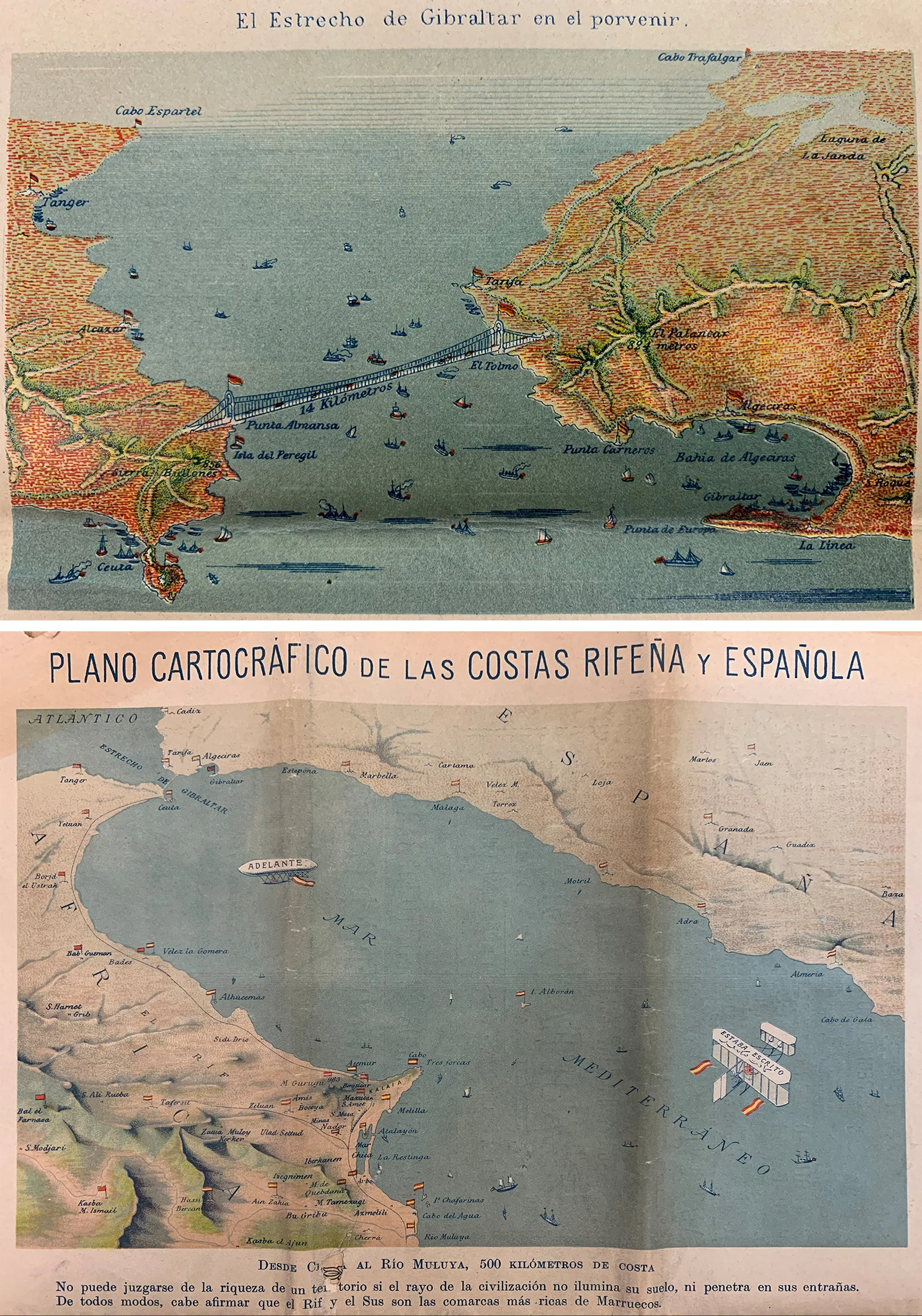
Figures 2 and 3. Cover and back cover of España en África from October 1, 1909, portraying the Iberian Peninsula and Morocco as united by an imaginary bridge. Z/14531, Biblioteca Nacional de España.
These materials thus gave concrete form to this moment of perceived crisis and helped organize how it could be imagined and articulated, even beyond the immediate realm of colonial material gains that the bridge image was attempting to convey. For example, concerns about mass politics and women’s suffrage—a common trope across Western Europe at the time—were often framed in explicitly spatial terms. Public intellectuals would warn that the expansion of political participation would “bridge the boundary between colony and metropole,” allowing for “savages to emerge onto the stage of civilization through a trap door.” [2] The fear of social and political change was thus articulated as a problem of spatial permeability—one not dissimilar to that evoked by the imaginary bridge in the magazine cover.
A shared spatial grammar thus began to emerge, circulating through mundane and highly visual venues that bypassed the limits of class and literacy, from kiosks and newspaper stands to the stamps and postcards that mediated everyday communication. It included images of ruins and loss, but also projections of extension and reconnection, articulating crisis through the language of landscape and territory—of blurred borders, ruinous domestic landscapes, and distant and fanciful colonial horizons.
““The imperial geography that had once anchored both had disappeared, and no stable alternative had yet taken its place.””
This spatial grammar cut across political projects. It was mobilized by actors with very different agendas: so-called regenerationist intellectuals (reformist thinkers seeking to “regenerate” Spain after imperial decline), colonial military officers, Krausist-socialist politicians (combining liberal-reformist pedagogy with socialist commitments), and Catalan and Basque nationalists all drew on similar spatial tropes to diagnose Spain’s condition and propose solutions. What circulated, then, was a set of spatial tropes rather than a unified ideology, structuring how problems and possibilities, collapse and rebirth, could be imagined.
It is within this environment that fascism began to take shape, not as a radical break with these discourses, but as a political formation capable of capturing and reorganizing them with particular force. It appropriated a spatial grammar that was already widely available and redirected it toward its specific project of national resurgence. Under the fascist narrative, the imagery of ruins became a dramatic stage on which new charismatic leaders could appear. The projections toward Africa were rearticulated as necessary and almost predestined steps toward regeneration. The collapsing distinctions between past and present were reorganized into a narrative of historical continuity, in which the Catholic Kings would somehow lift Spain from its ruinous present into a glorious future. As the inaugural article of the Revista de Tropas Coloniales, launched in 1924 by General Gonzalo Queipo de Llano and Francisco Franco, then still a colonial officer, put it:
Figure 4. 1ª Cruzada: España orientadora espiritual del mundo. Barcelona: Servicio Nacional de Propaganda, ca. 1939. Source: Biblioteca Nacional de España (BNE), CART/489. Also reproduced in: Hugh Thomas, La Guerra Civil Española: Carteles, Libro VII. Madrid/Barcelona: Hyspamérica–Ediciones Urbión, 1979/1980. Permission: Public domain (anonymous authorship; Spanish Civil War period). Courtesy of the Biblioteca Nacional de España.
“After having reached the highest degree of splendor in an era when «the Sun never set on its dominions», Spain began its decadent march, as if obeying a fateful law that appears to govern the destinies of nations (...) Fortunately, the horror inspired by the impending catastrophe and the anxiety that all of us, good Spaniards, felt for our regeneration, birthed a few men of heart who, risking everything, undertook the challenging task of reviving the dormant Spanish spirit that had been lulled by the Muslim fatalism that seems to pervade every corner of Spain. They are the ones that will lead Spain down a path that could make it worthy of its glorious history.” [3] In this process, the fascist promise of national rebirth acquired a concrete spatial form. It was no longer only a matter of restoring historical time, but of extending, reconnecting, and reimagining the geography and landscapes of the ruinous nation. The article’s reference to the former Empire Where the Sun Wouldn’t Set under the Catholic Kings was thus at once an invocation of a mythical past and an attempt to posit the fascist project as the seamless continuation of an already imaginable spatial order (Figures 4 and 5).
Figure 5. Anonymous. España resucita. Barcelona: Servicio Nacional de Propaganda / Gráficas Ultra, 1939. Source: Biblioteca Nacional de España (BNE), CART/494.Also reproduced in: Hugh Thomas, La Guerra Civil Española: Carteles, Libro VII. Madrid/Barcelona: Hyspamérica–Ediciones Urbión, 1979/1980. Permission: Public domain (anonymous authorship; Spanish Civil War period). Courtesy of the Biblioteca Nacional de España.
What fascist movements achieved, then, was the strategic alignment of a new political vision with a spatial imaginary that was already taking shape. They transformed a diffuse set of representations into a coherent horizon of action capable of rallying others behind it.
At this point, the fascist studies literature becomes particularly illuminating. In the last few decades, some of the most influential accounts of fascism have insisted on treating it not simply as a reactionary politics, but as a project of renewal capable of generating an exhilarating vision of the future, however terrifying and violent that future might be. Against earlier interpretations that reduced fascism either to a reactionary response to the failed promises of modernity or to the violent arm of capitalism at a moment of diminishing returns, scholars since the cultural turn have increasingly discussed fascism as a revolution in its own right. One of the most well-known and concise definitions to emerge from this literature is Roger Griffin’s formulation of fascism as “palingenetic ultranationalism”: a political project organized around the promise of rebirth.
In these accounts, fascism gained traction not only by responding to crisis, often through fear or violence, but by transforming crisis into a horizon of possibility. It articulated a future in which a perceived moment of decline could be overcome through the reactivation of a mythic past. The appeal of fascism, then, lay not only in what it opposed, but in the kind of future it made imaginable—a future experienced by many of its adherents as exhilarating rather than merely repressive.
This emphasis on rebirth resonates with a broader diagnosis of modernity articulated by Max Weber. Writing at the turn of the twentieth century, Weber described modern life as marked by a process of disenchantment (Entzauberung): the erosion of magical, sacred, and mythic frameworks of meaning under the advance of rationalization, bureaucracy, and scientific thought. In Weber’s account, the world had become increasingly intelligible and ordered, but also stripped of enchantment.
“What is being produced here is not simply a fantasy of territorial extension. Rather, it signals a shift in how time and space can be conceived as entangled and acted upon.”
Following this logic, fascism can be read, in part, as a response to this condition. It was not a simple return to a premodern past, but an attempt to reintroduce a sense of destiny, myth, and historical purpose into a disenchanted world. The fascist promise of political rebirth—and its appeal—thus involved a reorganization of how time itself was experienced: how past, present, and future could once again cohere and be given a sense of destination.
The Spanish case shows us that this promise of rebirth was articulated not only temporally, but spatially—through a set of images, maps, and spatial representations that made that future appear both visible and attainable. The reenchantment of time required a map: a concrete set of representations through which that future could be rendered conceivable, naturalized, and capable of gaining traction. In this sense, fascism can be understood not merely as a reactionary politics, but as a technology for producing futurity, one whose power lay in its ability to co-opt an existing spatial grammar—of ruins, collapsing borders, and imperial horizons—and redirect it toward its own project of palingenetic regeneration that would return the country to the stream of capital-H History. Its success, in other words, was not only political but imaginative: by capturing the language through which Spain’s crisis had already been diagnosed, fascism reinforced the sense that national rebirth could only be articulated through the spatial vocabulary of empire and expansion.
If this is the case, then the study of fascism—and of contemporary ethnonationalisms more broadly—requires attention not only to discourse and institutions, but to the spatial imaginaries through which political futures become imaginable. Such imaginaries do not simply accompany political projects. They help shape the conditions under which those projects can be conceived, communicated, and pursued.
The present moment of rising ethnonationalism across the globe brings new urgency to these questions and demands further research. Indeed, Griffin’s ideas of palingenetic ultranationalism still resonate today in slogans that promise to make countries “great again” or in the very names of neofascist parties like the Greek Χρυσή Αυγή (Golden Dawn, in reference to a bright new beginning). We are far from 1900, when Weber wrote about disenchantment, but the erosion of Enlightenment ideologies of rationality as progress is still in play, and can be seen in the breakdown of the secular sense of direction offered by welfare and developmentalist regimes across the globe—something that fascist movements seek to resolve by pointing to a new fanciful El Dorado. The explosion of magazines, newspapers, and newscasts—i.e., the rise of mass media—that accompanied early fascisms is long gone, yet the eruption of highly visual social media demands attention.
““… the act of renaming does not simply alter a label; it repositions a space within a broader narrative of national rebirth, projecting the U.S. concretely onto the world in a moment when globalization has made boundaries ambiguous.””
Consider, for instance, recent proposals to rename the Gulf of Mexico. Such gestures might appear superficial or merely rhetorical—acts of symbolic excess rather than substantive political interventions. Yet, much like the imagined bridge between Spain and Morocco, they operate by reconfiguring a geographical referent in ways that exceed their immediate designation. Here, the act of renaming does not simply alter a label; it repositions a space within a broader narrative of national rebirth, projecting the U.S. concretely onto the world in a moment when globalization has made boundaries ambiguous. Similar operations can be observed in the invocation of hemispheric boundaries—where acts of war are framed not in terms of rights or governance, but as matters internal to a “Western Hemisphere”—or in proposals concerning territorial extensions in the Arctic. In each case, what is at stake is not only material extraction, geopolitical advantage, or economic gain—which it is—but also the production of a spatial horizon within which certain political narratives can be imagined and articulated.
What distinguishes these contemporary examples from the early twentieth-century Spanish case is thus not the presence or absence of spatial imagination, but its mediation. Where illustrated magazines, atlases, and postcards once disseminated a shared spatial grammar, today highly visual and rapidly circulating social media perform a similar function, albeit at a different speed and scale, and delivered intimately to one’s phone or computer. The underlying operation, however, remains comparable: the alignment of political aspiration and temporal promise with a reconfigured sense of space.
As the Spanish case demonstrates, these gestures are not merely symbolic or rhetorical, but should be understood as attempts to reshape the spatial horizon within which political futures become thinkable. Before a future can be implemented, it must be imagined; and before it can be imagined, it must be given a form—often a geographical one.
Rebirth, it turns out, needs a map.
Citation
Pol Fité Matamoros, “Mapping Fascism: What Spain’s Past Reveals About the U.S. Today,” PLATFORM, May 11, 2026.
Notes
[1] Joaquín Costa, quoted in the Revista de Geografía Colonial y Mercantil, Year IV (1900), no. 6, p. 569, Biblioteca Nacional de España.
[2] The first quotation is from Gustav Le Bon’s influential The Crowd (1895). The second is from the Spanish public intellectual José Ortega y Gasset, La rebelión de las masas (1930; n.p.: Clásicos de Historia, 2016), p. 32.
[3] Gonzalo Queipo de Llano, “Our Purpose,” Revista de Tropas Coloniales, January 1, 1924. Biblioteca Nacional de España.