Exploding the City
Britain’s twentieth-century new towns are rightly celebrated as landmarks in architectural and planning history. They have long attracted considerable attention and continue to inspire much work by historians. These places were, as Guy Ortolano has suggested, the ‘spatial dimension of the Welfare State’.[1] In other words, as the creations of central government, the new towns embodied many of the economic and social aspirations of the modern British state. They were intended to be transformative: to offer a new way of life through the provision of well-designed housing and skilled jobs; to drive the modernisation of the economy by encouraging new industries.
““...as the creations of central government, the new towns embodied many of the economic and social aspirations of the modern British state.””
The new towns represented the coming together of various lines of thought.[2] Not least among them were the ideas of Ebenezer Howard, which inspired ‘garden cities’ internationally. In Britain, these debates came into focus during the late 1930s and 1940s.[3] They led in time to the 1946 New Towns Act, which introduced a process for the creation of new towns across England, Scotland and Wales by public-sector ‘development corporations’, i.e. unelected bodies which worked in parallel to the established structures of (elected) local government. Insulated from short-term electoral cycles, the development corporations could plan and build for the long term, working with the voluntary sector and also, by the 1960s, the private sector to co-ordinate the provision of housing, jobs, shops and leisure facilities. With subsequent legislation introducing a similar process in Northern Ireland, thirty-two new towns were begun between 1946 (Stevenage) and 1973 (Stonehouse). Although enabled by a single process, these places varied in size, form and purpose. However, renewed emphasis from the late 1970s on inner-city regeneration, coupled with neoliberal political shifts, saw the winding down of the new towns programme by the 1990s.[4]
Figure 1. Volume 1 of the Central Borders plan: the inner title page (Open Government Licence)
The development corporations’ sense of their own significance – and their public-sector status – meant that they not only promoted their activities extensively but that they also often retained substantial archives. As a result, they offer much to the architectural historian, and indeed the historian of modern Britain more generally. They are also a particular focus for contemporary debate, in view of the current UK government’s plan to build a further set of new towns in England. Yet a focus on the new towns alone is to ignore other kinds of planned new community in post-war Britain. Some of these alternatives are at least as relevant – perhaps even more relevant – as models for consideration today. They include places which were developed by local government, by other kinds of public-sector bodies such as the Scottish Special Housing Association, and by the private sector.
As an example, we might take the Central Borders area of Scotland. A plan for this area was commissioned by the Scottish Development Department – an arm of central government – in 1966 and was published in 1968.[5] The study team was based at the University of Edinburgh, and was led by Percy Johnson-Marshall, a prominent modernist planner who had worked in Coventry and London before in the mid-1950s beginning a new career combining practice and academia. Within a context in which architectural research was growing in prominence, along with inter-disciplinary understandings of the ‘built environment’, he led a research unit which undertook a range of studies.[6] Most of these studies were of urban environments; the Central Borders study is distinctive among the unit’s work on account of its focus on a rural area.
Figure 2. Map showing the Borders area, from the Central Borders plan (Open Government Licence)
The Central Borders, around fifty miles south of Edinburgh, was (and remains) a patchwork of small towns and villages set in an undulating landscape. It is an area of rich farmland which also has a strong industrial heritage, not least in textile production. By the middle of the twentieth century, however, industrial decline was among several factors which were leading to depopulation; the Central Borders study was to consider how this depopulation might be reversed.
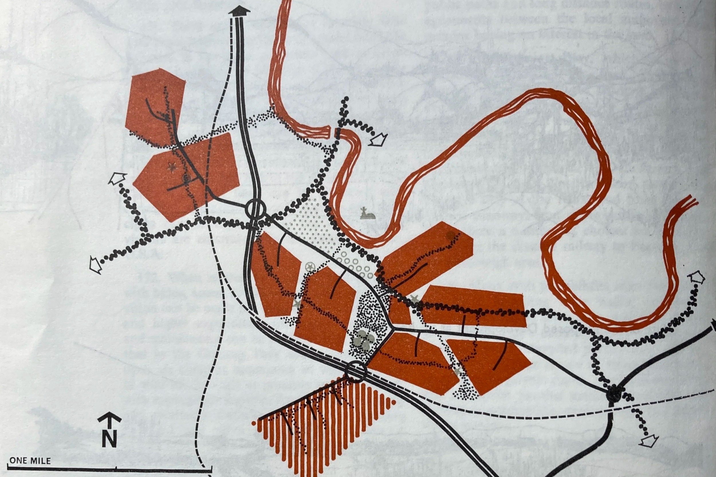
The study team’s response was that the area could be understood as a ‘regional city’. Such phrasing might suggest a concerted programme of urbanisation, but Johnson-Marshall’s ideas were more subtle than that. They were inspired by increasing levels of personal mobility (i.e., car ownership) and correspondingly decreasing levels of ‘time distance’, as well as an understanding that rising educational standards and affluences were leading to demands for improved housing, amenities and environmental standards. The report imagined the Borders as a city ‘exploded’ across the countryside into a series of distinct communities, among which new housing, work and leisure facilities would be dispersed. Between them, improved though still modestly scaled roads would offer rapid connections, in essence recreating the kinds of journey times and access to facilities that might be found in a conventional urban area. The result, the report suggested, represented ‘tomorrow’s living’.
Figure 3. Proposals for the expansion of St Boswells as a small new town (Open Government Licence)
The idea of an ‘exploded city’ is not without a history, evoking Ebenezer Howard’s ‘town-country’ concepts as well as the theories of Patrick Geddes, who in the early twentieth century emphasised the connections between urban areas and their rural hinterland. However, regional planning was very much in vogue during the 1960s.[7] There are parallels with the dispersed ‘circuit linear’ urban layouts proposed by the likes of Gordon Cullen as well as several of the new towns begun at the end of the decade, such as Peterborough, Irvine, Central Lancashire and especially Milton Keynes, where the American theorist Melvin Webber’s vision of ‘community without propinquity’ informed a layout in which different land uses were spread across a regular grid plan. The Central Borders plan thus offered a distinctive interpretation of ideas which were then in vogue.
In some ways, the Central Borders plan might feel like a less than exciting adjunct to the more dramatic, even photogenic architecture of the new towns or, indeed, the comprehensive urban redevelopments of the 1950s and 1960s. It stands apart from the controversial boldness of Glasgow’s highways, Cumbernauld’s megastructural town centre, or the adventurous housing of early Milton Keynes; indeed, when it talks about architecture, the Borders report is modest and contextual. Furthermore, its impact might seem limited. Its most eye-catching proposal – a small new town at St Boswells – came to nothing. Indeed, the subsequent history of the area has been informed by social and economic pressures that have emerged since the late 1960s, along with new technological and industrial opportunities. The reopening in 2015 of the railway connection to Edinburgh – unanticipated by the 1960s planners, who accepted its then-proposed closure – has created a different kind of ‘city region’
Figure 4. Overall proposals for the Central Borders, 1968 (Open Government Licence)
Yet in many ways the report has had a fundamental influence on the area’s physical and economic development. It lent its support to existing proposals for a ‘new community’ (a mini new town) at Tweedbank, proposed and developed by the Scottish Special Housing Association. New and improved roads have been built on the lines set out by the study team, and a major new general hospital was constructed during the 1980s in the location which they proposed.[8] Their emphasis on encouraging tourism continues to shape developments, such as a new holiday complex just beginning construction near Selkirk. The urban population level has declined slightly on its mid-1960s level, but appears to have stabilised.
““The report imagined the Borders as a city ‘exploded’ across the countryside into a series of distinct communities, among which new housing, work and leisure facilities would be dispersed.”
By proposing that infrastructural improvement and some housebuilding would allow the Central Borders to offer the kind of amenities and quality of life associated with a major urban area while retaining its distinctive character, the report was both radical and modest. It evoked the optimism and ambition of the 1960s, and, like the new towns, sought to drive social and economic change by means of land-use planning. However, in making a series of modest moves it also anticipated the more pragmatic economic (and architectural) climate of the 1970s and 1980s. In this respect, it demonstrates the extent to which the planners of those decades developed the frameworks laid down during the ‘white heat’ era. And in the current context of restrained public expenditure, it suggests the value of limited but targeted interventions on a broad canvas, looking across a region in a co-ordinated way and planning for the medium and long term. Ultimately, seductive as the new towns are for the historian (not least this one), it emphasises the need to look beyond them (and comprehensive redevelopment), in order fully to understand how planning and architecture reshaped late twentieth-century Britain – and how they might do the same in the future.
Citation:
Alistair Fair, “Exploding the City,” Platform, August 31, 2026.
Notes:
[1] Guy Ortolano, Thatcher’s Progress: From Social Democracy to Market Liberalism Through an English New Town (Cambridge: Cambridge University Press, 2019), 3.
[2] Elain Harwood, ed. Alistair Fair, New Towns Mark One: Architecture and Planning in Post-War Britain (Swindon: Historic England, 2026), chs. 1-2.
[3] Alistair Fair, Lynn Abrams, Kat Breen, Miles Glendinning, Diane Watters and Valerie Wright, Building Modern Scotland: A Social and Architectural History of the New Towns, 1947-1997 (London: Bloomsbury, 2025), 1-22.
[4] See e.g. Alistair Fair, ‘Stonehouse: Scotland’s Last New Town, c. 1967–1977’, Urban History 50, no. 4 (2023), 818–39.
[5] Scottish Development Department, The Central Borders, 2 vols. (Edinburgh: HMSO, 1968).
[6] See e.g. Juliana Yat Shun Kei, Inventing the Built Environment: Planning, Science and Control in British Architecture (Abingdon: Routledge, 2024).
[7] See e.g. Otto Saumarez Smith, Boom Cities: Architect-Planners and the Politics of Radical Urban Renewal in 1960s Britain (Oxford: Oxford University Press, 2019).
[8] Harriet Richardson Blakeman, ‘Medicine and Modernity: Fifty Years of NHS Hospital Building in Scotland’, Ph.D. dissertation, University of Edinburgh, 2024, pp. 205-14.